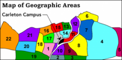
Breakdown of the Ottawa Carleton Region:
The following is a brief guide to the areas of the City as they are categorized on our listing boards and maps.
1. Ottawa West: Baseline to the North, Merivale to the West,Colonnade to the South, Prince of Wales to the East. Includes the neighbourhoods of Fisher Heights, Carleton Heights, Parkwood Hills, Skyline.
2. Hunt Club: Airport Parkway to the East, Ottawa International Airport to the South, Rideau Canal to the West, CN rail line to the North.
3. South Keys: Johnston Rd. to the North, Airport Parkway to the West, Hawthorne to the East, Lester Rd. to the South. Includes the neighbourhoods of Greenboro, Blossom Park, Upper Hunt Club, the South Keys Shopping Centre and the South Keys and Greenboro Transitway stops, and the Greenboro O-Train stop.
4. Gloucester: Aviation Parkway to the West, Innis to the South, Rockcliffe Parkway to the North. Includes the neighbourhoods of Beacon Hill North and South, Pineview, and Blackburn Hamlet, as well as the Blair Transitway Station.
5. Orleans: East of Blackburn Hamlet. Includes a Transitway station at the Place D’Orleans Shopping Centre. Rockcliffe-Hemlock to the South, Rideau River to the West, Aviation Parkway to the East, Rockcliffe Parkway to the North. Includes the Village of Rockcliffe, New Edinburgh, Manor Park.
6. Rockcliffe: Hemlock to the South, Rideau River to the West, Aviation Parkway to the East, Rockcliffe Parkway to the North. Includes the Village of Rockcliffe, New Edinburgh, and Manor Park.
7. Vanier: Rideau River to the West, Aviation Parkway to the East, Queensway to the South, Beechwood/Hemlock to the North. Includes the neighbourhood of Overbrook, the St. Laurent Shopping Centre, and the St. Laurent Transitway station.
8. Alta Vista: Alta Vista Drive to the West, Heron/Walkley to the South, St. Laurent to the East, Queensway to the North. Includes the neighbourhoods of Elmvale, Southvale, Pleasant Park, and the Smyth, Abby and Hurdman Transitway stops.
9. Billings Bridge: CN rail line to the North, Heron Rd./Alta Vista Drive to the East, Riverside to the North, Airport Parkway to the West. Includes the neighbourhoods of Heron Gate Village, Heron Park, Billings Bridge Shopping Centre, Ellwood, the Walkley, Heron, Billings Bridge and Pleasant Park Transitway, and the Confederation O-Train stops.
10. Mooney’s Bay: Prince of Wales to the West, Airport Parkway to the East, Heron Rd. to the North, CN Rail line to the South. Includes Prince of Wales complex, Hog’s Back, Riverside Park.
11. Ottawa South: Adjacent to Carleton University. Colonel By Drive to the North, Rideau River to the South, Bronson to the West, Queensway to the East. Includes the neighbourhoods of Old Ottawa South, Old Ottawa East, Rideau Gardens.
12. Lowertown: Sussex to the North, Rideau River to the East, Rideau Canal to the West, Queensway to the South. Includes the University of Ottawa, and the neighbourhoods of Sandy Hill and the Byward Market, as well as Mackenzie King, Laurier, and Campus Transitway stops.
13. Centretown: Queensway to the South, Preston to the West, Wellington to the North, the Rideau Canal to the East. Includes the downtown core, Golden Triangle, and downtown Transitway stops.
14. Glebe: Queensway to the North, Preston to the West, Rideau Canal to the South and East. This includes Bell and Cambridge St. South.
15. Civic: Carling to the South, Island Park Drive to the West, Preston to the East, Ottawa River Parkway to the North. Includes the neighburhoods of Civic Hospital, Hintonburg, Mechanicsville, Little Italy, and the Tunney’s Pasture Transitway stop, and Bayview and Carling O-Train stops.
16. Westboro: Ottawa River Parkway to the North and West, Island Park Drive to the East, Carling to the south. Includes the Carlingwood and Westgate shopping Centres, and the Lincoln Fields and Westboro Transitway stops.
17. Experimental Farm: Fisher to the East, Maitland to the West, Carling to the North, Baseline to the South.
18. Algonquin: Viewmount to the South, Woodroffe to the West, Merivale/Maitland to the East, Carling to the North. Includes the neighbourhoods of Bel Air Heights, Navaho, City View and Algonquin College
19. Nepean South: West Hunt Club to the North, Prince of Wales to the East, Hwy 416 to the West, Strandherd to the South. Includes the neighbourhoods of Barrhaven, Pine Glen, riverside South and the Fallowfield Transitway stop.
20. Nepean: Baseline to the North, Hwy 416 to the West, West Hunt Club to the South, Woodroffe and Viewmount to the East. Includes the neighbourhoods of Centrepointe, Craig Henry and Tanglewood and the Baseline Transitway stop.
21. Pinecrest: Bordered by the Ottawa River to the North, Woodroffe to the east, Baseline to the South, Hwy 416 to the west. Includes the neighbourhoods of Britannia and Bayshore and the Iris and Queensway Transitway stops.
22. Bell’s Corners: Between Pinecrest and Kanata
23. Kanata: West of Bell’s Corners (Not shown on map above)